


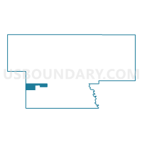
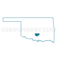
Voting District 11, Garvin County, Oklahoma
About
Outline

Summary
| Unique Area Identifier | 654009 |
| Name | Voting District 11 |
| County | Garvin County |
| State | Oklahoma |
| Area (square miles) | 9.11 |
| Land Area (square miles) | 9.03 |
| Water Area (square miles) | 0.08 |
| % of Land Area | 99.12 |
| % of Water Area | 0.88 |
| Latitude of the Internal Point | 34.60557480 |
| Longtitude of the Internal Point | -97.51205200 |
Maps

Graphs
Select a template below for downloading or customizing gragh for Voting District 11, Garvin County, Oklahoma


Neighbors
Neighoring Voting District (by Name) Neighboring Voting District on the Map
- Voting District 12, Garvin County, OK
- Voting District 14, Garvin County, OK
- Voting District 55, Stephens County, OK
- Voting District 9, Garvin County, OK
Top 10 Neighboring County Subdivision (by Population) Neighboring County Subdivision on the Map
Top 10 Neighboring Place (by Population) Neighboring Place on the Map
Top 10 Neighboring Unified School District (by Population) Neighboring Unified School District on the Map
Top 10 Neighboring State Legislative District Lower Chamber (by Population) Neighboring State Legislative District Lower Chamber on the Map
- State House District 42, OK (37,553)
- State House District 51, OK (37,430)
- State House District 22, OK (36,386)
Top 10 Neighboring State Legislative District Upper Chamber (by Population) Neighboring State Legislative District Upper Chamber on the Map
- State Senate District 24, OK (98,936)
- State Senate District 14, OK (76,649)
- State Senate District 13, OK (73,191)